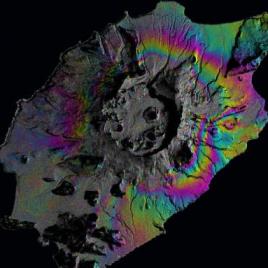
Scientists are learning to use satellite imaging and mathematical calculations to better predict volcanic activity. Modern satellite technologies, similar to GPS, can now track the ground movements that happen as magma shifts beneath the Earth’s surface. A team of geoscientists are pioneering the use of a process called data assimilation, which incorporates new measurements with […]
Tag: earthquakes
A new way to forecast earthquakes with gravity signals
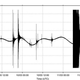
Current early-warning earthquake systems rely on so-called seismic waves, which are produced in the Earth during the rupture. But a new study found another method that could indicate an earthquake even earlier. By analyzing data from the 2011 Tohoku earthquake off the coast of Japan, researchers have identified a prompt gravity signal that precedes seismic […]
Chilean earthquake wasn’t the one scientists expected
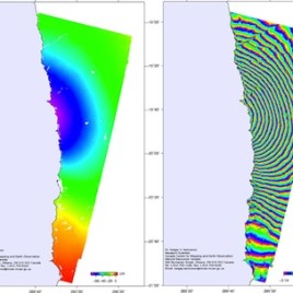
Scientists had long expected a major earthquake in the subduction zone adjacent to northern Chile, but the magnitude 8.2 earthquake that occurred on April 1, 2014 was not it, according to a new study. Stress along the fault had been building since the last major quake in the area occurred in 1877. However, an analysis […]
Groundwater depletion in California may move mountains
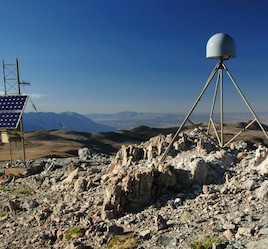
Removal of groundwater in California’s San Joaquin valley may be causing small seismic events, according to a new paper. Researchers used GPS measurements to show that land surrounding the valley is rising by between 1 and 3 mm per year, in response to draining of the underlying aquifer. The pattern is correlated with wet and […]