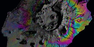
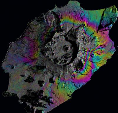
Each set of fringe corresponds to a ground movement of ~3 cm.
(Image via the Institut des Sciences de la Terre (ISTerre)
Scientists are learning to use satellite imaging and mathematical calculations to better predict volcanic activity. Modern satellite technologies, similar to GPS, can now track the ground movements that happen as magma shifts beneath the Earth’s surface. A team of geoscientists are pioneering the use of a process called data assimilation, which incorporates new measurements with a dynamical model, to learn how to better predict volcanic activity. This type of process is already widely used among meteorologists and climate change scientists to make predictions based on changing variables such as the weather patterns or carbon emissions. Geoscientists still need to improve current volcanic models before they can be widely applied to real-life volcanoes, but some are already beginning to test their methods on the Grímsvötn Volcano in Iceland and the Okmok Volcano in Alaska.
Authors:
M. Grace Bato, Virginie Pinel and Yajing Yan
Corresponding author:
Mary Grace Bato, ISTerre, Université Savoie Mont Blanc, Campus Scientifique, Le Bouget-du-Lac, France, Grace.Bato@univ-smb.fr
Original paper published in Frontiers in Earth Science on June 28, 2017.